
Introducing the Mountain Directory Ebooks!
 |
From the author, RW: When customers find out that I’m from Kansas, they often say, “Kansas? What can you tell me about mountain passes if you’re from Kansas?” But after they hear my story, they cut me a little slack. (By the way, did you know that there was once a researcher with too much government grant money who determined that Kansas actually is flatter than a pancake?) When I was a kid in the early 60’s my parents owned a 16 foot Mobil Scout travel trailer. We pulled that trailer all over the western United States and Canada with a 1962 Chevy with a 283 cubic inch engine and a three speed on the column. So I learned to love mountains and I learned to love traveling the wide open spaces of our great land. With that small trailer and the reliable Chevy, we never had any problems climbing or descending grades. VITAL INFORMATION FOR ANYONE DRIVING A LARGE OR HEAVY VEHICLE In an attempt to make mountain driving a little safer for truckers and RV’ers, R&R Publishing Inc. has been collecting and The printed versions of the Mountain Directory books had almost 240 pages of text and color relief maps. All 240 pages are in the downloadable versions of the Mountain Directory ebooks. Nothing is missing. In the printed versions, mountain pass locations were marked with a yellow triangle on the color relief maps. In the ebook versions, you can click on the yellow triangles and the text appears that describes that location.
There are three summits along this stretch of US 33. The eastern summit is between Rawley Springs, VA and Brandywine, WV. The east side is 4 miles of 8 to 9% grade. The west side is 4½ miles of 9% grade and both sides have continuous sharp curves and hairpin turns. The highway is two lane on both sides. The middle summit is between Oak Flat and Franklin, WV. The east side of this hill is 2½ miles of 8% with 25 mph curves. The west side is about 3½ miles of much milder grade. It is 4 to 5% over most of its length. There are some sharp curves near the bottom. The road is two lane on both sides of the hill. The western summit is between Franklin and Judy Gap, WV. It is 5 miles of steady 9% grade on both sides. Both sides are two lane with sharp curves and hairpin turns. Use caution on this road. |
 publishing information about mountain passes and steep grades since 1993. The
 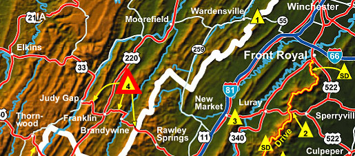 4. US 33 (between Harrisonburg, VA and Judy Gap, WV.)
CLICK HERE FOR FULL DETAILS
Travel with safety – safety from knowledge and information about navigating through the Mountain Grades and Terrain.


